The British Isles
|
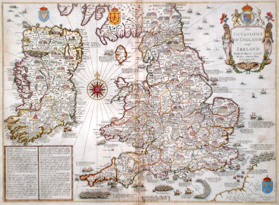
The British Isles 'The Invasions of England and Ireland with al their Civill Wars since the conquest' Speed, J. (c. 1676) 52 x 39 Very interesting and famous map engraved by Cornelius Dankerts for editions of John Speed's Theatre published with the Prospect. The map is based on an early map of the British Isles by John Speed and particularly The Isle of Man and Ireland have different outlines compared to later Speed maps. A large number of battles taking place in the British Isles are engraved on the map. Of particular note is the formation in the English Channel of the Spanish Armada. Fire ships and the consequent scattering of the armada are depicted and wrecked Spanish ships around the northern coasts and Ireland. English text verso. Later hand colour. An unobtrusive old repair to the right, not affect the engraving, otherwise condition excellent. 1450.00 GBP |


|
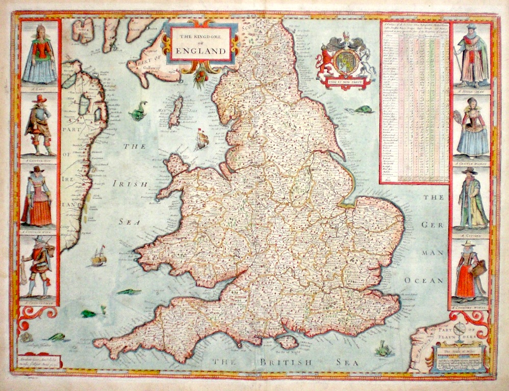
The British Isles 'The Kingdome of England' Goos, A. (c. 1676) 52 x 38 Superb example of John Speed's map of England and Wales from the "Theatre of The Empire of Great Britain" Bassett and Chiswell edition. The map acknowledged to be being based on that of Christopher Saxton. This copy is from the new plate engraved by Abraham Goos and included in "The Theatre" from about 1632, the earlier plate having become too worn. Although similar from the point of view of topographical detail the new plate shows considerable differences from the earlier one with regard to the decorative detailing. English Text verso. Good margins and very fine original colour. 1100.00 GBP |
|
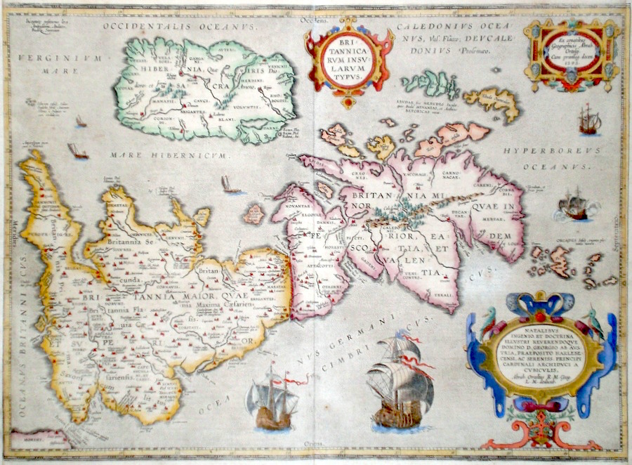
The British Isles 'Britannicarum Insularum Typus' Ortelius, A. (c. 1618) 50 x 37 Superb map of classical Britain by Abraham Ortelius. Published by Petrus Bertius in the Atlas "Theatrum Geographiae Veteris". This rare atlas compiled by Bertius used purchased Ortelius copperplates and other plates from Mercator to publish a classical atlas similar to the Ortelius Parergon. Features include three fine cartouches, and four galleons with other sailing vessels in the ocean, emphasising Britains's maritime traditions. Latin text to verso. Later hand colour. Condition - trimmed vertical margins, otherwise excellent. 650.00 GBP |
|
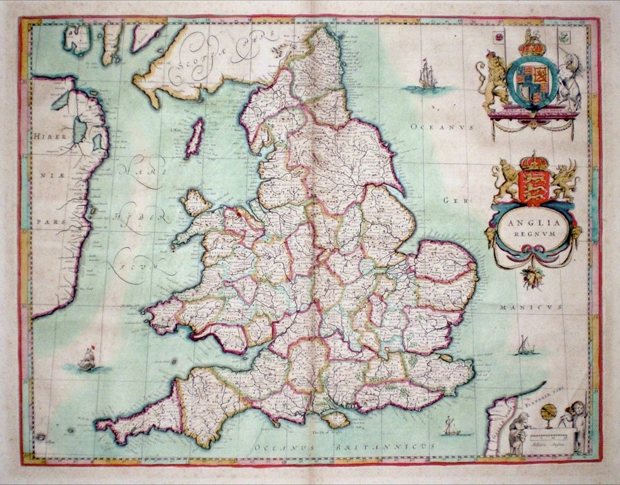
The British Isles 'Anglia Regnum' Blaeu, W. (c. 1635) 50 x 38.5 Elegantly engraved map of England and Wales by Willem Blaeu. Decorative features include two Heraldic cartouches and decorative mileage scale. One small repaired hole otherwise condition is excellent. W. Blaeu (1571-1638) founder of the Blaeu printing house in Amsterdam. 440.00 GBP |
|
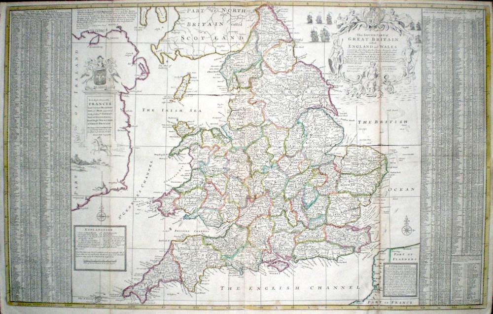
The British Isles 'The South Part of Great Britain Called England and Wales….. Moll, H. (c. 1740) 98 x 61 Herman Moll's large size and very attractive map of England and Wales. Features include: extensive tables of the Principal towns to right and left. Many roads are marked, some which Moll states are "not to be found in Mr Ogilby's book". A very fine main cartouche with a maritime theme and inhabitants of overseas colonies with their wares. The area of Ireland is decorated with engraved pastoral scenes. Explanation panel, advertisement, dedication panel and compass rose. Old vertical folds, (as often found with this map), skilfully strengthened verso. Otherwise generally excellent condition. Original colour. Ref Shirley "Printed maps of the British Isles" Moll 6, state 6. 325.00 GBP |
|
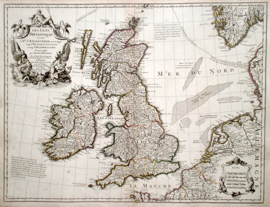
The British Isles 'Les Isles Britaniques ou Sont Le Rme. D'Angleterre...' De Lisle, G. (c. 1702) 61 x 47 Very finely engraved map of the British Isles by Guillaume Del'Isle, generally recognised as one of the most significant cartographers of his time. Published in Paris, the map features a fine nautical themed title cartouche in which D'lisle recognises the debt owed to Speed for England. Pont for Scotland and Petty for Ireland. The map also shows large areas of the northern European coastline up to Sweden. Early colour. Condition excellent. (Shirley-Printed maps of the British Isles -Delisle 1, state 1) 295.00 GBP |
|
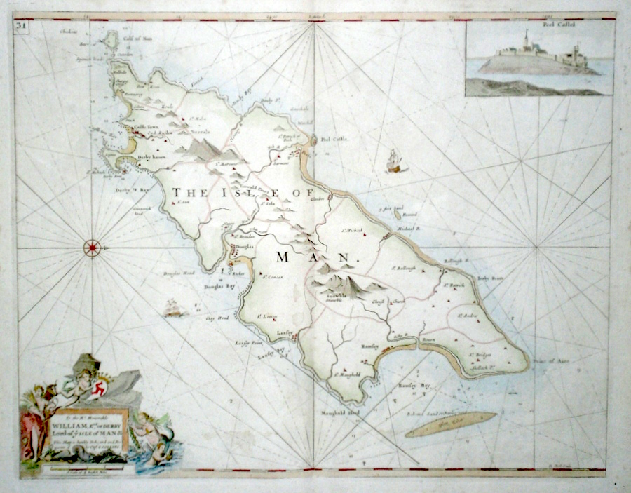
The British Isles 'The Isle of Man' Moll, H. (c. 1750) 57 x 45 Finely engraved sea-chart and map of the Island by Herman Moll for Grenvile Collins' Great Britain Coasting Pilot. The celebrated engraver Moll contributed some works to this first British Sea Atlas from about 1693. (engraved signature lower right). Features include a fine dedication cartouche lower left, and top right, a view of Peel Castle. Later colour. Large folio map with good margins. 295.00 GBP |
||||||||||||||
|
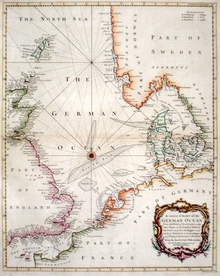
The British Isles 'A Correct Chart of the German Ocean' Seale, R. (c. 1745) 38 x 48 A finely engraved and detailed chart of The North Sea by Richard Seale. Published in Tindal's translation of Paul Rapin De Toras's History of England. The map features extensive coastal details on the countries bordering the North Sea and the extensive shoals and sandbanks found there. Excellent condition. Later colour. 285.00 GBP |
|
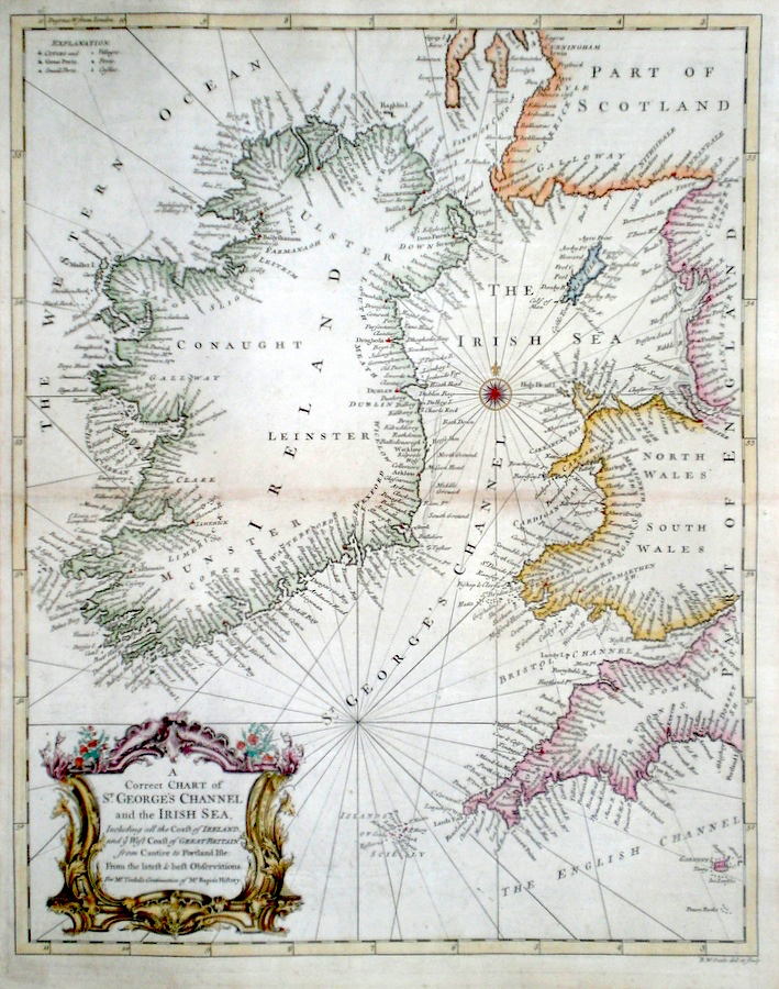
The British Isles A Correct Chart of St. George's Channel and the Irish Sea….. Seale, R. (c. 1745) 38 x 48 A finely engraved and detailed chart of The Irish Sea and St. George's Channel by Richard Seale. Published in Tindal's translation of Paul Rapin De Toras's History of England. The map features extensive coastal details on the countries bordering the St. George's Channel and includes the complete island of Ireland. Excellent condition. Later colour. 275.00 GBP |
|
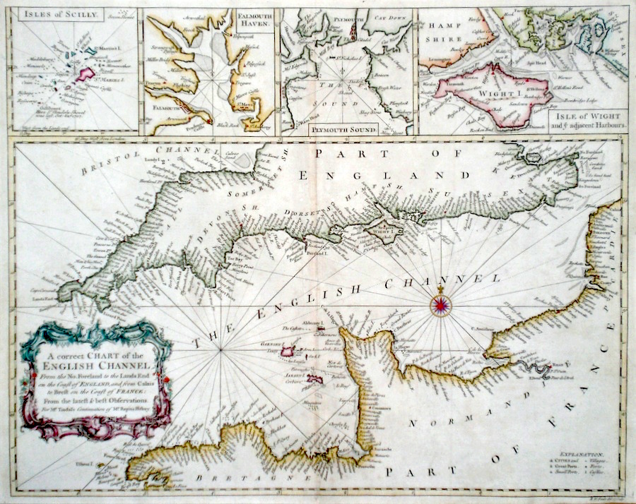
The British Isles 'A Correct Chart of the English Channel...' Seale, R. (c. 1745) 38 x 48 A finely engraved and detailed chart of The English Channel by Richard Seale. Published in Tindal's translation of Paul Rapin De Toras's History of England. The map features extensive coastal details on the countries bordering the Channel and includes inset charts of Isles of Scilly, Falmouth Haven, Plymouth Sound and The Isle of Wight and adjacent Harbours. Excellent condition. Later colour. 265.00 GBP |
|
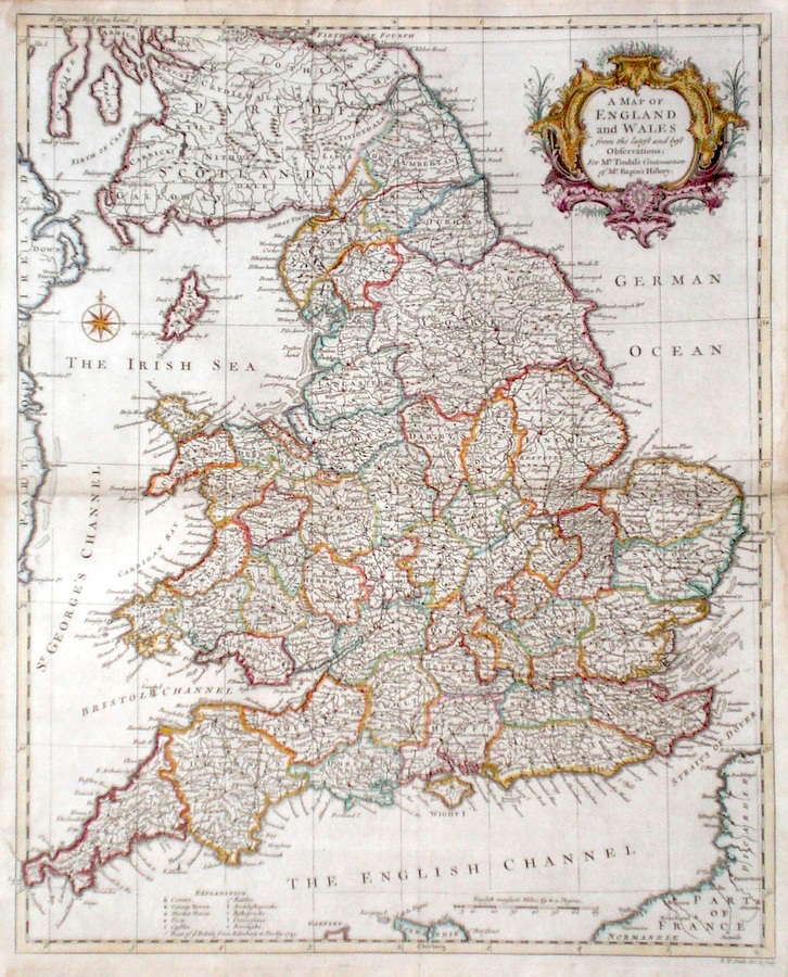
The British Isles 'A Map of England and Wales from the latest and best Observations...' Seale, R. (c. 1745) 38 x 47 A finely engraved and detailed map of England and Wales by Richard Seale. Published in Tindal's translation of Paul Rapin De Toras's History of England. The map features extensive detail on the Kingdom and has a particularly fine title cartouche. Excellent condition. Later colour. 245.00 GBP |
|
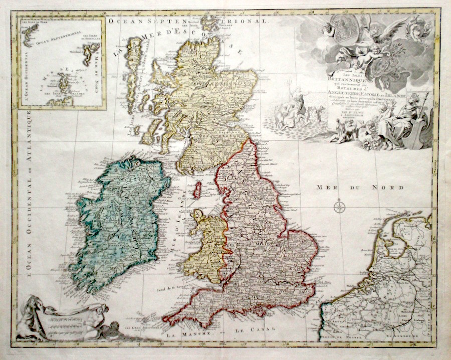
The British Isles 'Les Isles Brittaniques qui contiennent les Royaumes d' Angleterre Escosse, et Irlande...' Jaillot, A-H. (c. 1792) 60 x 48 Impressive map of the British Isles by Alexis-Hubert Jaillot. First issued in 1695, this map, a later state issued by the Amsterdam publishers Elwe c. 1792. Features include an extensive cartouche showing mythological land, water, and heavenly scenes. Inset map of the Orkney and Shetland Isles. Early colour, condition excellent. (Shirley-Printed maps of the British Isles-Jaillot 4, state 5) 225.00 GBP |
|
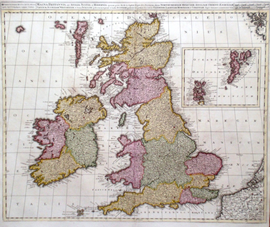
The British Isles 'Magna Britannia aut Anglia, Scotia et Hibernia...' Valk, G. & L. (c. 1705) 59 x 49 Fine, large, early map of England and Wales, by Gerard and Leonard Valk, father and son publishing in Amsterdam. Features include large and attractive inset map of Orkney and Shetland colour. Condition generally excellent. 225.00 GBP |
|
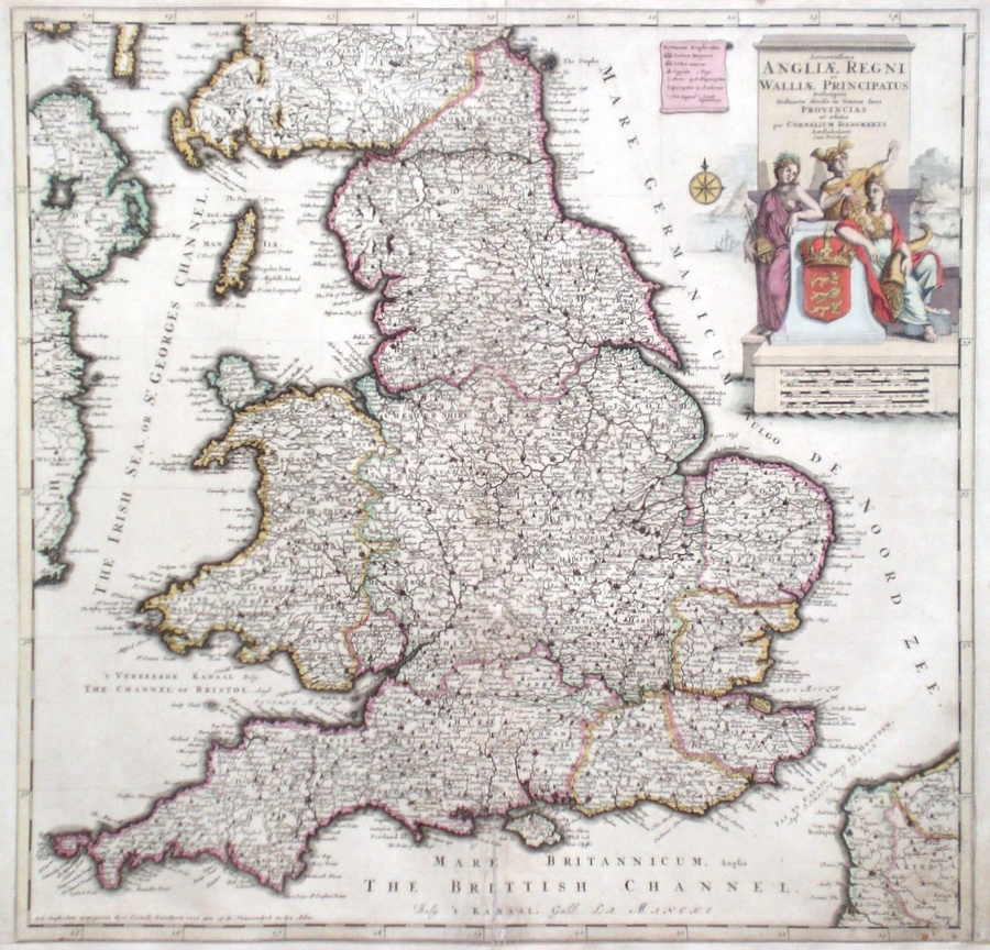
The British Isles 'Accuratissima Angliae Regni et Walliae Principatus...' Dankerts, C. (c. 1696) 53 x 52 Fine, large, early map of England and Wales, Published by Cornelius Dankerts in Amsterdam. The map is detailed and shows the main road routes between the major towns. Features include large and attractive cartouche. Early colour. Remargined to the bottom and restoration to the extreme right hand corner. Bottom central fold repaired verso. Condition generally good. 195.00 GBP |
|
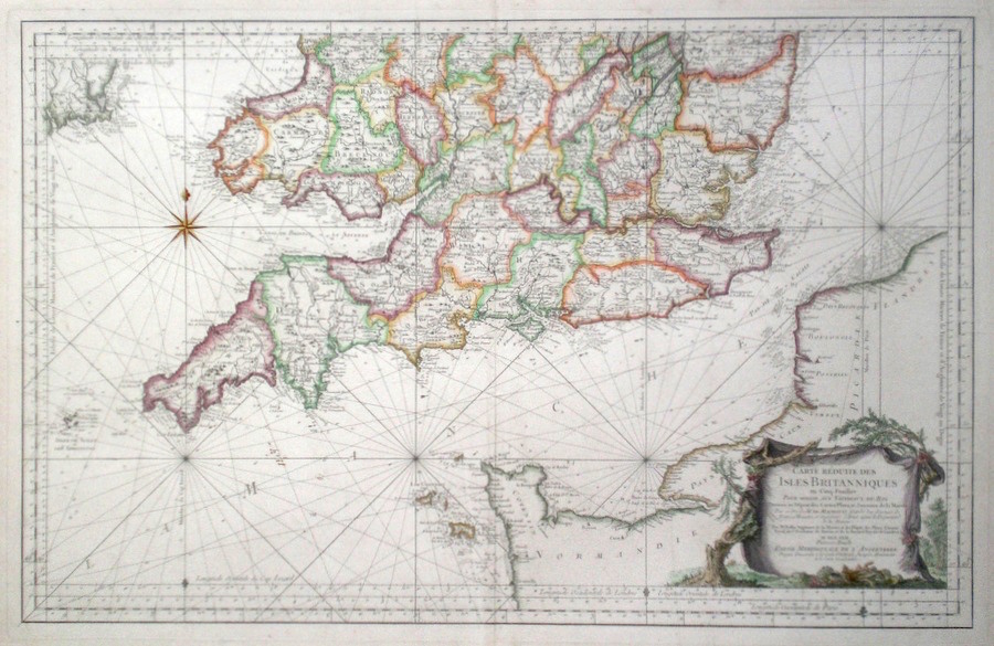
Southern England 'Carte Reduite Des Isles Britanniques Partie Meridionale De L' Angleterre' Bellin (c. 1757) 87 x 56 Fine sea chart by Bellin of southern England, the English Channel and northern French coasts of the Channel. One of a set of five covering the British Isles. Features include a fine cartouche. Later colour. This copy laid down on acid free paper and will be sent packed flat. 200.00 GBP |
|
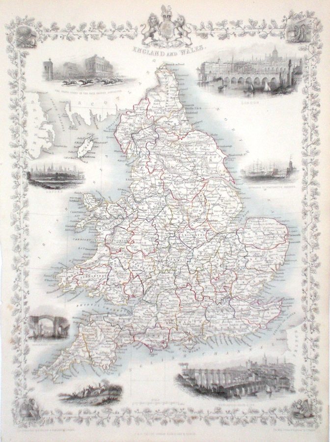
The British Isles 'England and Wales' Rapkin, J. (1851) 26 x 35 Superb map of England and Wales, engraved by John Rapkin, for John Tallis's highly decorative "The Illustrated Atlas". The vignettes show; London, The Grandstand Doncaster Racecourse, Oxford Portsmouth Harbour, Newcastle-upon-Tyne, Sunderland Bridge, and a sporting scene. In the corners of the border are also small vignettes of various industries. Single page map (no central fold). Original outline colour to each county, as published. Condition fine. 200.00 GBP |
|
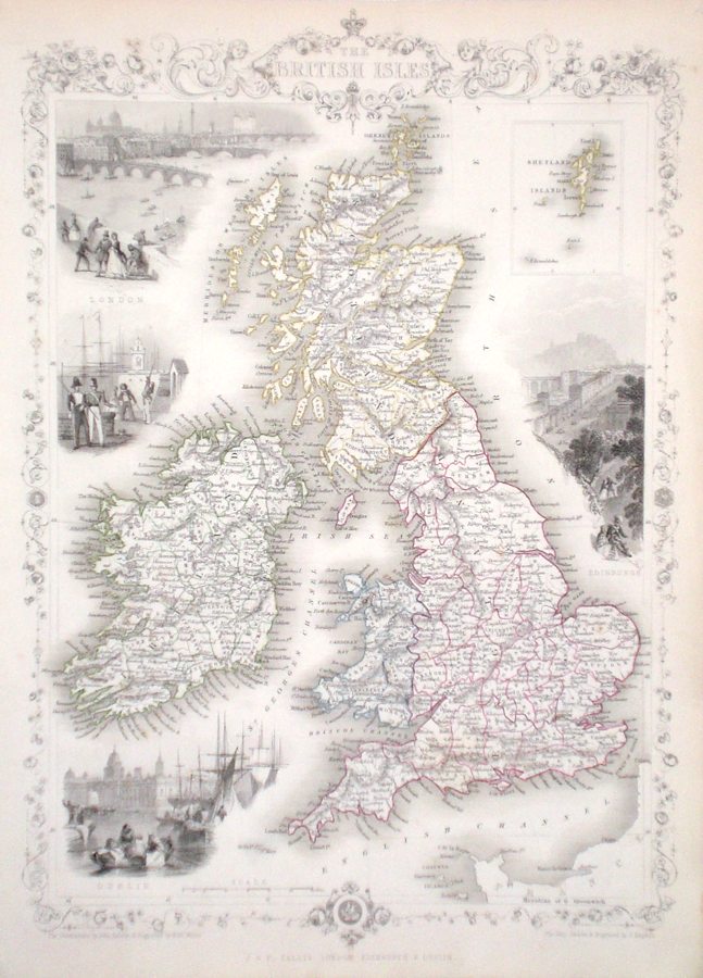
The British Isles Rapkin, J. (1851) 26 x 35 Superb map of The British Isles, engraved by John Rapkin, for John Tallis's highly decorative "The Illustrated Atlas". The vignettes show; London, Edinburgh, and Dublin. Single page map (no central fold). Original outline colour as published. Condition fine. 200.00 GBP |
|
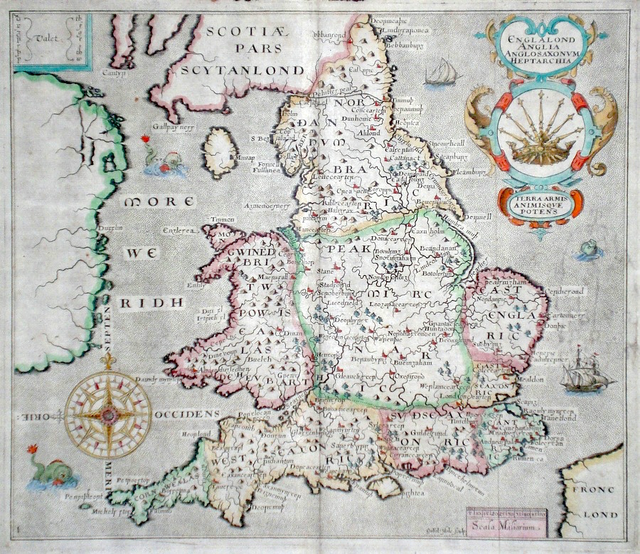
England 'Englalond Anglia Anglosaxonum Heptarchia' Hole, W. (c. 1610) 33 x 28 Finely engraved map of England and the Heptarchy by William Hole for the first edition of Camden's Britannia to contain county maps. The finely composed engraving features three sea-monsters and two ships in the seas around the country, large compass rose and attractive cartouche. Later colour. Excellent condition 185.00 GBP |
|
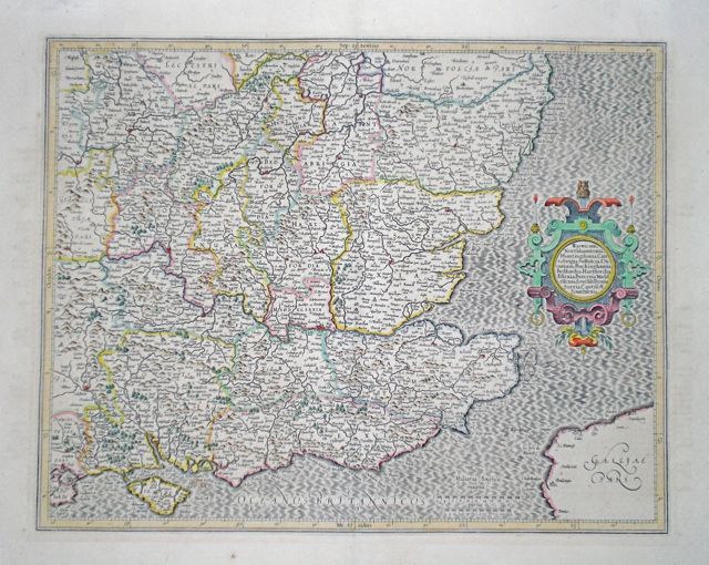
South East England 'South East Counties' Mercator, G. (c. 1607/1613) 47 x 37 Superb early map of the South East Counties from Mercator's Atlas. First appearing in 1595 with Latin text, this edition with French text published after Hondius purchased Mercator's plates. Later colour. 185.00 GBP |
|
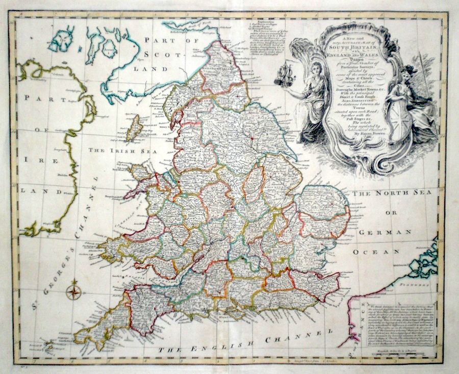
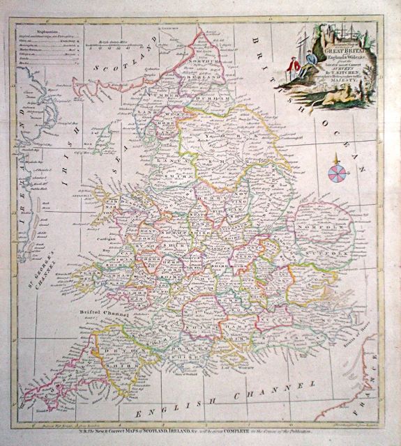
The British Isles 'A New And Very Accurate Map of South Britain or England and Wales...' Bowen, E. (c. 1752) 42 x 35 Detailed and finely engraved map of England and Wales By Emanuel Bowen engraved for the publication "A Complete System of Geography". The map features a large and attractive cartouche (engraved by Thomas Kitchin) containing the extensive full title. Other additional areas of information are also contained on the map. An uncommon item. Later colour. 160.00 GBP |
|
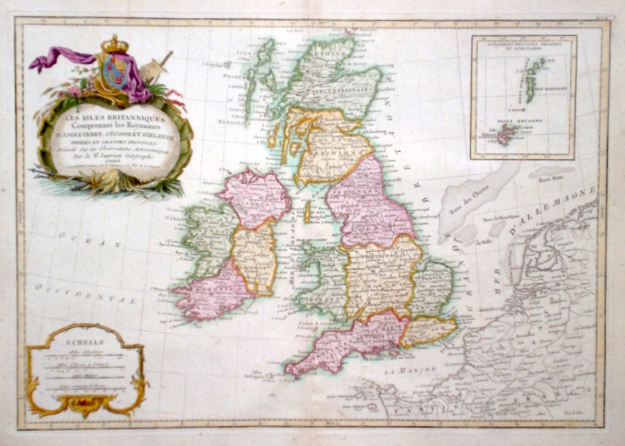
The British Isles 'Les Islkes Britanniques Comprenant Les Royaumes D'Angleterre, D'Ecosse, et D'Ireland...' Janvier, J. (c. 1759) 45 x 31 Finely engraved map of the British Isles by Jean Janvier, published by Lattre, Bordeaux. Features include an attractive title cartouche, and inset map of the Orkney and Shetland Isles. Condition excellent. 160.00 GBP |
|
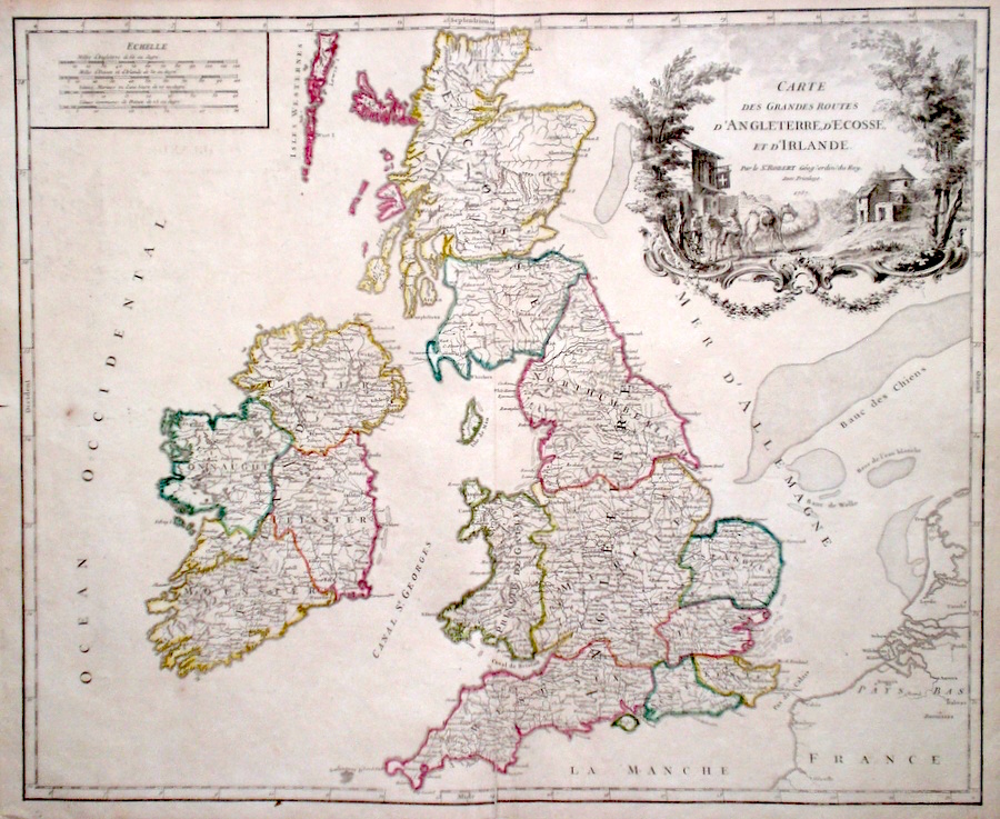
The British Isles 'Carte Des Grandes Routes D'Angleterre, D'ecosse, et D'Ireland' de Vaugondy, D. R. (c. 1757) 57 x 47 Fine, large map of the British Isles by the important French cartographer Didier Robert de Vaugondy. A particular feature of the map is the extensive title cartouche featuring a rural scene. Condition excellent 155.00 GBP |
|
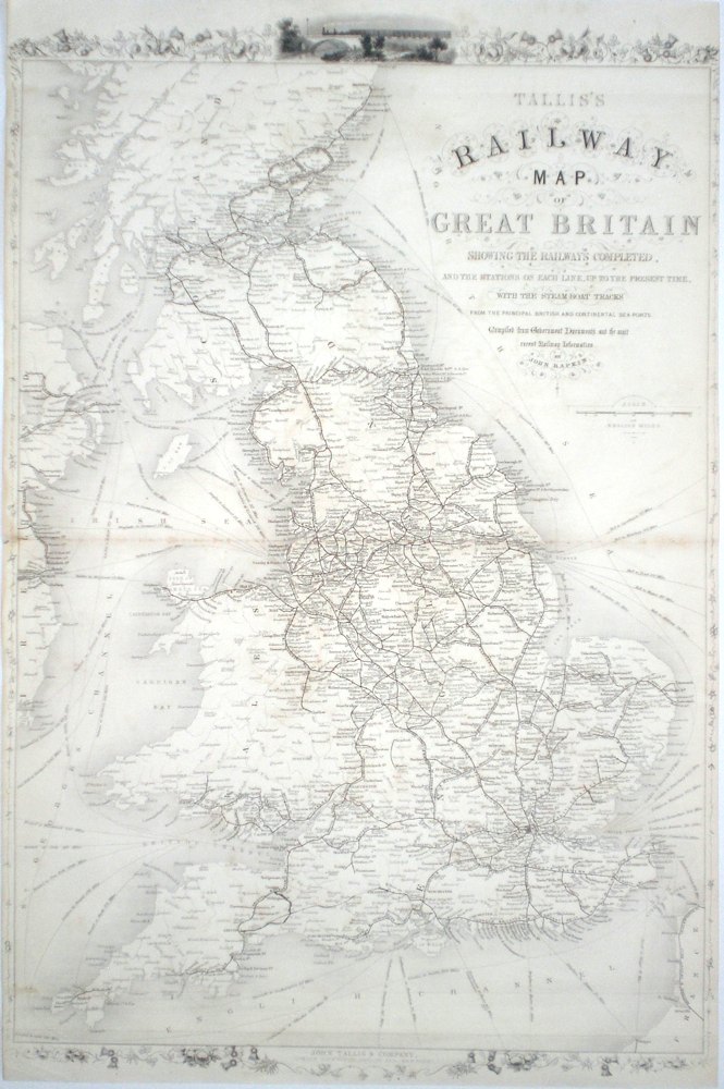
The British Isles 'Tallis's Railway Map of Great Britain' Rapkin, J. (1851) 36.5 x 55 John Tallis's comprehensive map of Britain's Railway system, engraved by John Rapkin. From Tallis's highly decorative "The Illustrated Atlas. A very interesting map, it also shows the steam-boat tracks from British and continental ports. Double page map, two horizontal folds as issued. Condition excellent. 150.00 GBP |
|
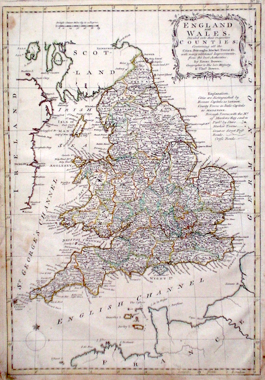
The British Isles 'England and Wales Divided into their respective Counties...' Bowen E. & T. (1767) 22.5 x 33 Very finely engraved map of England and Wales by Emanuel and Thomas Bowen from the "Atlas Anglicanus". A rare item. Bright original colouring. 145.00 GBP |
|
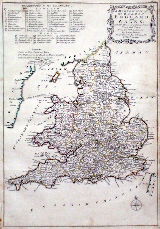
The British Isles 'A Modern Map of the Roads of England and Wales... Bowen E. & T. (1767) 22.5 x 33 Very finely engraved map of The Roads of England and Wales by Emanuel and Thomas Bowen from the "Atlas Anglicanus". The separate counties are delineated and the distances between towns is given alongside the roads. A rare item. Bright original colouring. 145.00 GBP |
|
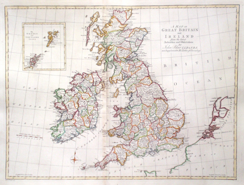
The British Isles 'A Map of Great Britain and Ireland from the latest Authorities and Observations' Blair, J. (1768) 56 x 43 Finely engraved map of The British Isles for John Blair's "The Chronology and History of The World". The Counties of England, Ireland, Scotland, and Wales are all separately delineated. An inset map shows Orkney and Shetland. Fine condition. Later colour. 140.00 GBP |
|
The British Isles 'A New and accurate map of that district of Great Britain called England and Wales..' Kitchen,T. (c. 1790) 35 x 38 Superbly engraved map of England and Wales from Spencer's History of England. Later hand colour. Traces of old folds but generally excellent condition 115.00 GBP |
|
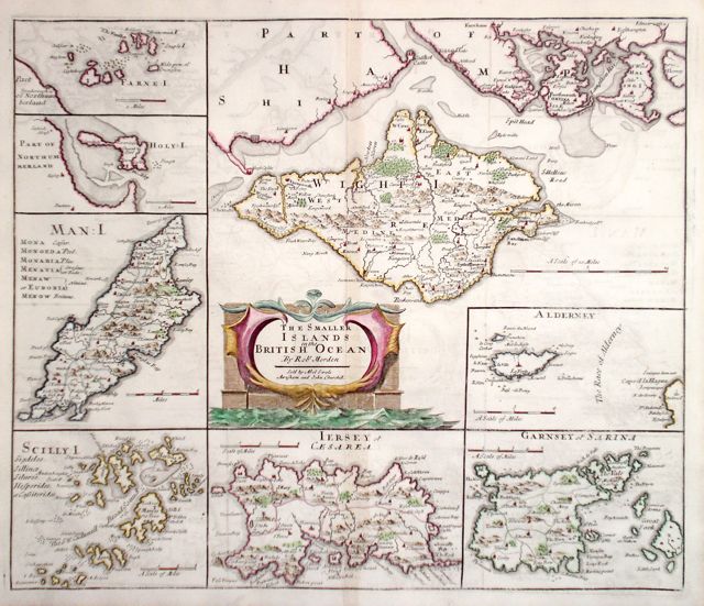
The British Isles 'The Smaller Islands in the British Ocean' Morden, R. (1722) 43 x 36 Composite map with maps of: Isle of Wight, Farne Islands, Holy Island, Isle of Man, Scilly Isles, and three maps of the Channel Isles. Dark engraving in fine condition. Later colour 100.00 GBP |
|
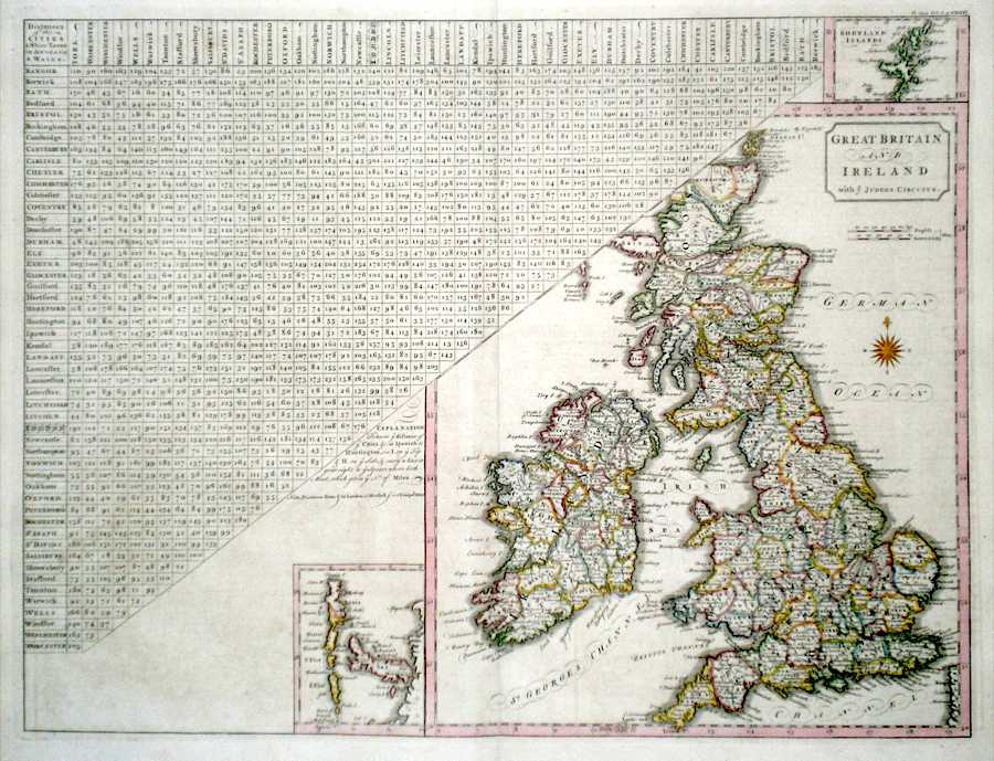
The British Isles 'Great Britain and Ireland with ye Judges Circuits' Cary, J. (1789) 48 x 36 Detailed and interesting map by John Cary for The First edition of Gough's translation of Camden's Britannia. Shows the British Isles with Judge's circuits and to the left a comprehensive table giving the distance between towns and cities in England and Wales. Also shown to the right is a comparison scale of English miles to "Scotch" and Irish miles. Later colour 100.00 GBP |
|
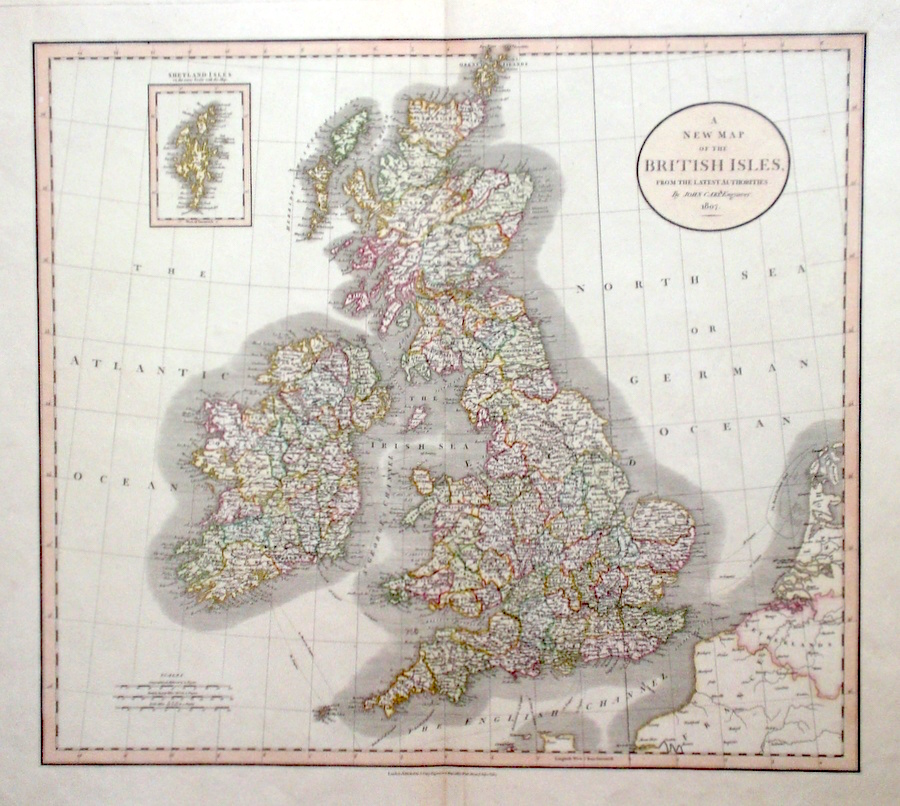
The British Isles 'A New Map of The British Isles From the Latest Authorities…' Cary, J. (c. 1807) 52 x 47 Fine double page map of The British Isles by John Cary. Inset map of The Shetland Isles. Original colour. Condition excellent 95.00 GBP |
|
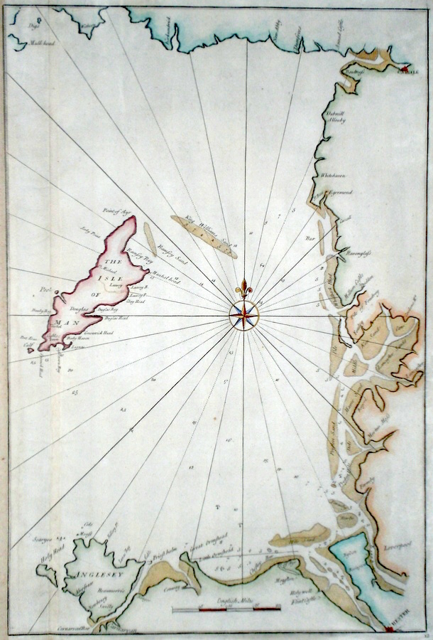
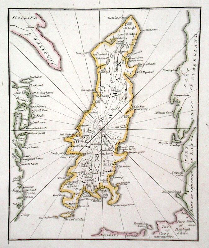
The British Isles Untitled sea chart Halley, E. (c. 1730) 34 x 51 Fine sea cart of the waters around the Isle of Man between the coast of North Wales, Southern Scotland, and the British mainland. By Edmund Halley & Nathaniel Cutler published in the Atlas Maritimus & Commercialis. Halley was one of England's foremost astronomers but was also an accomplished mapmaker and surveyor. Later colour 95.00 GBP |
|
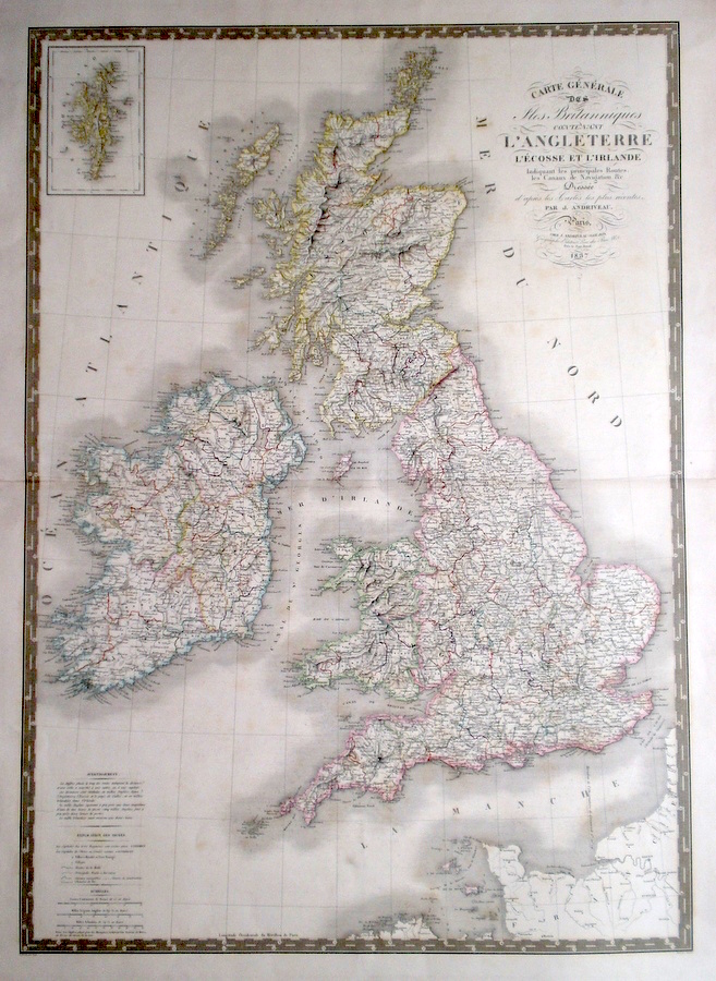
The British Isles 'Carte Generale Des Isles Britanniques, Contenant Angleterre, L'Ecosse, et L' Ireland...' Andrivau, J. (c. 1837) 61 x 86 Very large map of the British Isles by J. Andrivau-Gougon, and published in Paris. The map uses the meridian of Paris as the Prime meridian, thus London is between two and three degrees west of Paris. Original colour. Condition excellent 95.00 GBP |
|
The British Isles Hewitt, N. (c. 1817) 50 x 61 Fine, large map of the British Isles engraved by Nataniel Hewitt for Thomson's New General Atlas. Inset map of the Orkneys and Shetlands. Original colour. Condition excellent 95.00 GBP |
|
The British Isles 'A New most Accurate and Complete Map of all the Direct and the Principal Cross Roads in England and Wales...' Kitchin, T. (1784) 30 x 35 Fine double page map of England and Wales delineating all the major roads by Thomas Kitchin for Walpoole's "New and Complete British Traveller". Features include a title cartouche and a key numbering all the Counties. Later colour 85.00 GBP |
|
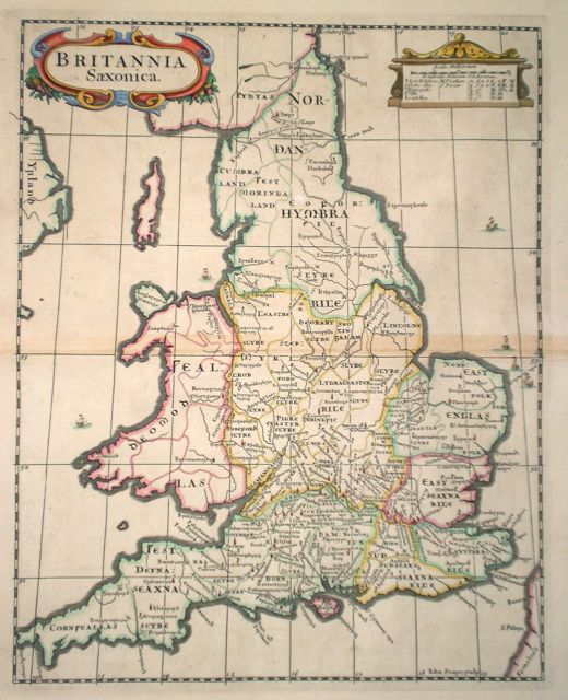
The British Isles Britannia Saxonica Sturt, J. (1722) 30 x 37 Saxon Britain from the 1722 edition of Camdenís Britannia. This map engraved by John Sturt. Good condition. Later colour. 85.00 GBP |
|
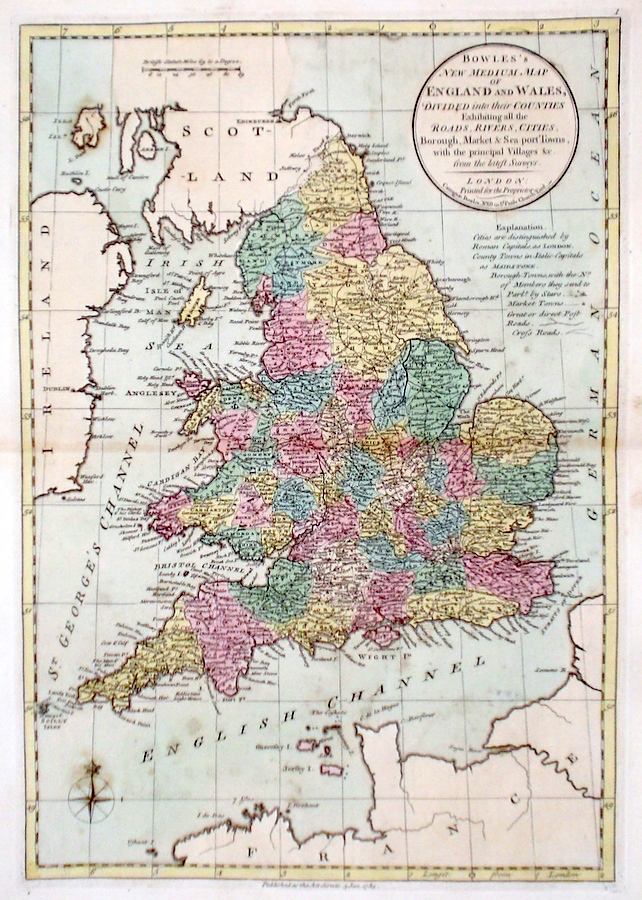
The British Isles 'Bowles's New Medium Map of England and Wales...' Bowen, E. & T. (1785) 23 x 33 Finely engraved and detailed map of England and Wales from "Bowles's New Medium English Atlas". The maps in this series are based on those in Emanuel and Thomas Bowen's Atlas Anglicanus, and feature extensive county information on the map. They are distinguished primarily by having newly engraved cartouches, distances from London added to towns, and different imprints at the bottom. Full original colour. Some slight marks to the lower part of the map but otherwise good condition. 75.00 GBP |
|
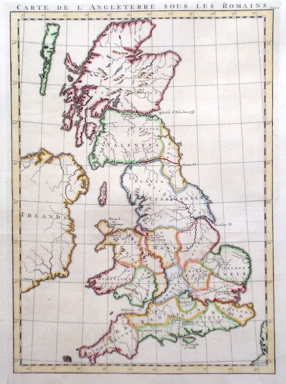
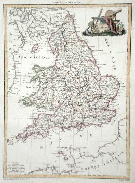
The British Isles 'Carte D'Angleterre sous Les Romains' Rapin De Thoras (c. 1727) 28 x 40 Interesting map of England and Wales showing the Roman divisions of the Country and the indigenous tribes present. Engraved for Paul Rapin de Thoras' History of England. Later colour. 75.00 GBP |
|
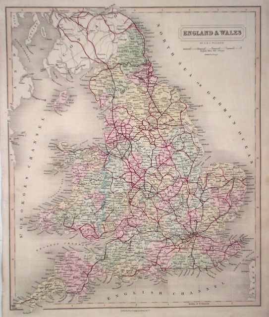
The British Isles 'England and Wales' Walker, J & C. (c. 1862) 33 x 40 Detailed map of England and Wales by J & C Walker featuring the extensive early railway system. Original colour. 75.00 GBP |
|
The British Isles 'England and Wales' Scott, R. (c. 1833) 43 x 49 Steel engraved map published by Archibald Fullarton for Bell's Gazeteer. Later colour. Fine condition 70.00 GBP |
|
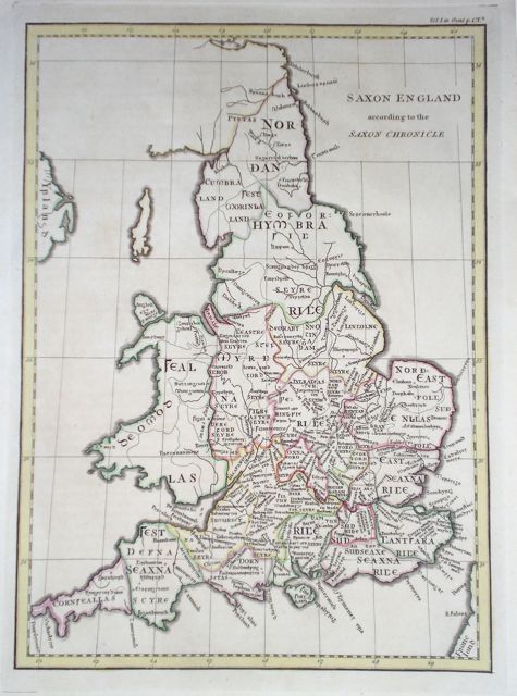
England 'Saxon England according to the Saxon Chronicle' Cary, J. (1789) 23 x 32 Finely engraved map with later hand colour from Camden's Britannia. The Saxon Chronicle was compiled from manuscripts written by monks from the 7th to the 9th century. 55.00 GBP |
|
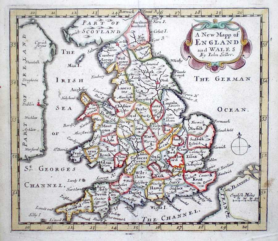
England 'A New Mapp of England and Wales by John Seller' Seller, J. (c. 1703) 15 x 13 Fine map of England and Wales by the Hydrographer and instrument maker John Seller for his "Anglia Contracta". The map shows all the counties in outline colour. 50.00 GBP |
|
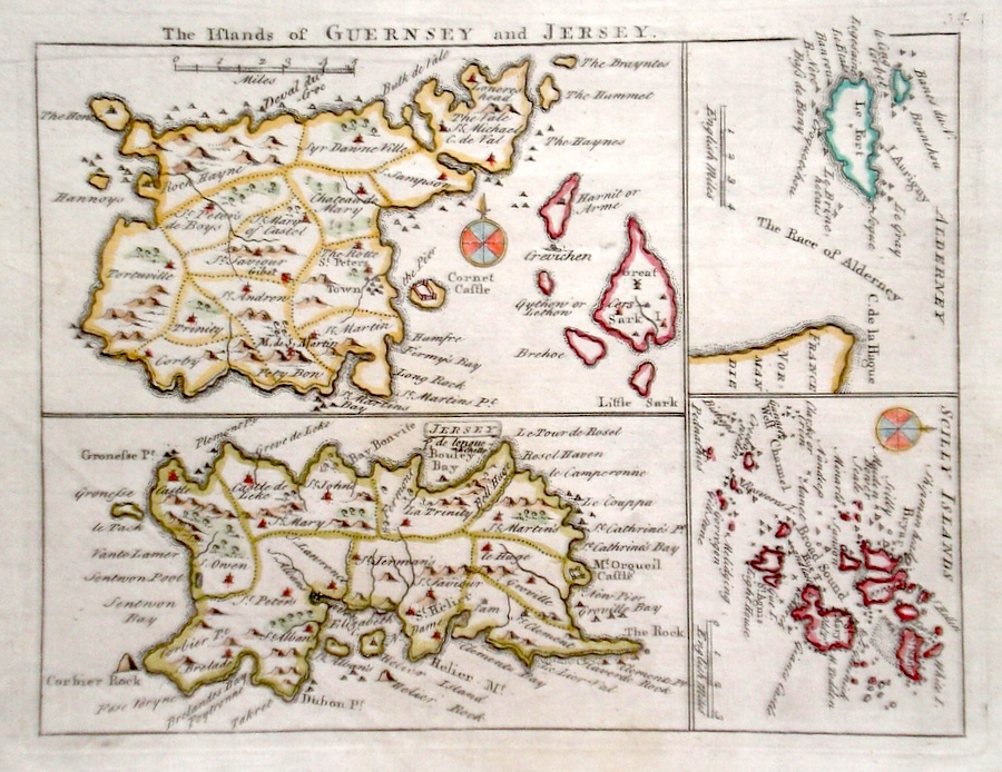
The British Isles 'The Islands of Guernsey and Jersey' Rocque, J. (c. 1769) 20 x 16 Finely engraved map of the Islands by John Rocque for the publication "England Displayed". Also included on the plate are separate maps of The Scilly Isles and Alderney. Later colour 50.00 GBP |
|
The British Isles
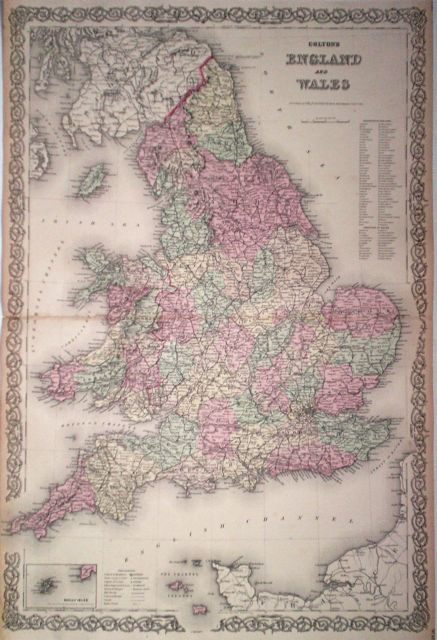
'Colton's England and Wales' Colton's Atlas of the World. (c.1856) 64 x 43 Large size and decorative map of England and Wales by the New York publishing house of G.W and C.B. Colton. Original colour 50.00 GBP |
|
South East England 'Des Konigreich's England Ostlicher Theil' Von Reilly (1781) 28 x 22 Hand coloured, attractive cartouche, good margins. 50.00 GBP |

|
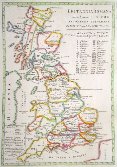
The British Isles 'Britannia Romana collected from Ptolemy. Antonines Itinerary, the Notitia and Inscriptions' Cary, J. (1789) 24.5 x 35 Map of Roman Britain showing Roman Tribes. Later Colour. 50.00 GBP |
|
British Isles Starling, T. (c. 1832) 9 x 15 The British Isles Finely engraved and uncommon map from The Royal Cabinet Atlas. Bright original colouring. 40.00 GBP |
|
British Isles 'England and Wales' Starling, T. (c. 1832) 9 x 15 Uncommon and finely engraved map of the two countries from The Royal Cabinet Atlas. A numbered key identifies each county. Bright original colouring. 40.00 GBP |
|
The British Isles Angleterre Lapie (c. 1829) 23 x 31 Attractive map of England by Chamouin for the Paris publishing House Lapie. Original colouring to each county. Interestingly as normal for French Cartographers at the time, the meridian runs through Paris. 40.00 GBP |
|
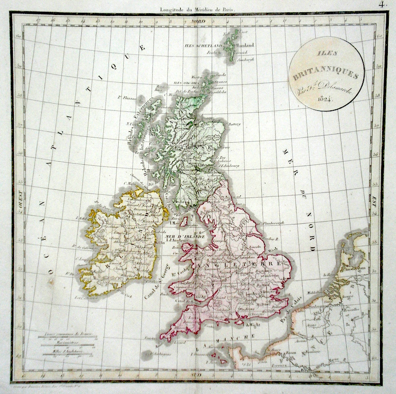
The British Isles Isles Britanniques Delamarche, C. F. (c. 1824) 28 x 29 Attractive map of The British Isles by the publisher and Cartographer Charles Francois Delamarche. Interestingly as normal for French Cartographers at the time, the meridian runs through Paris. 40.00 GBP |
|
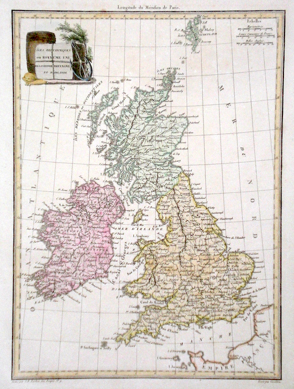
The British Isles 'Isles Britanniques ou Royaume Uni….' Tardieu, A. (c. 1811) 23 x 31 Attractive map of The British Isles by the publisher and Cartographer Amboise Tardieu. Interestingly as normal for French Cartographers at the time, the meridian runs through Paris. 40.00 GBP |
|
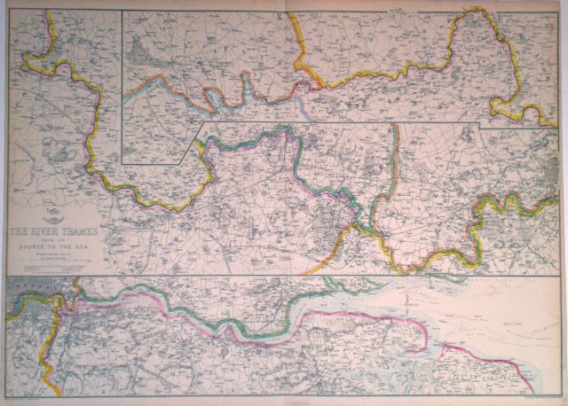
South East England The River Thames from its Source to the Sea Dispatch Atlas (1863) 63 x 46 Double page map of the river in three sections arranged on two sheets. Original colour. Excellent condition. 85.00 GBP |
|
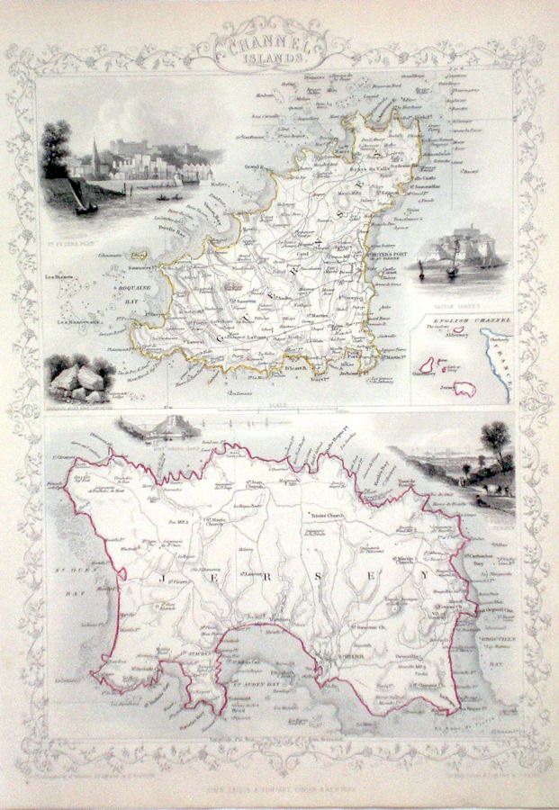
Channel
Islands Rapkin, J. (1851) 26 x 35 Two fine maps, Jersey and Guernsey engraved by John Rapkin, for John Tallis's highly decorative "The Illustrated Atlas". The vignettes show; View of St Peter's Port and Castle Cornet ,View of Jersey and Mont Orgueil Castle. Single page, separate maps, (no central fold). Original colour as published. Condition fine. 80.00 GBP |
|
Channel
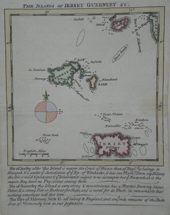
Islands 'The Islands of Jersey Guernsey &c.' Kitchin/Jefferys (1751) 13.5 x 18 Finely engraved map of the Islands by Thomas Kitchin and Thomas Jefferys from their publication "The Small English Atlas". This rare series of maps are distinctive by featuring considerable local information below the map. Later colour 60.00 GBP |
|
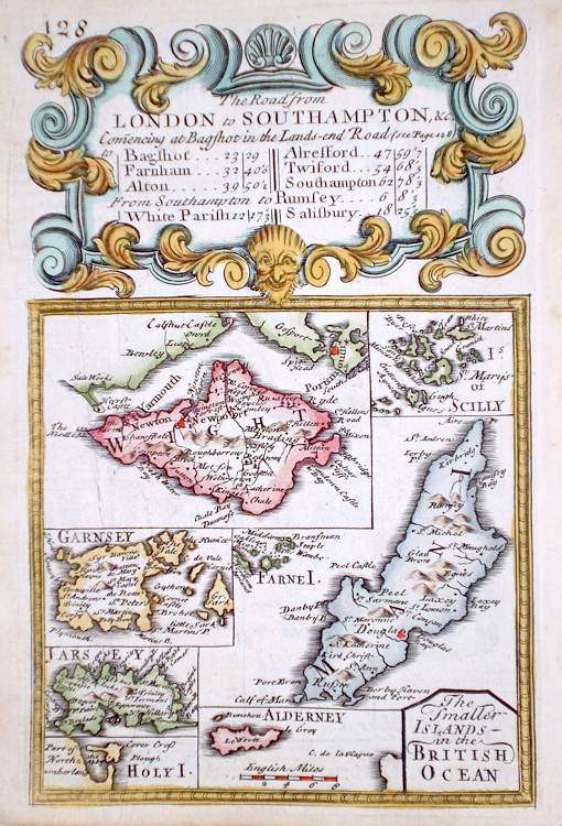
The British Isles 'The Smaller Islands in the British Ocean' Bowen E. (c. 1724) 12 x 19 Finely engraved map by Emanuel Bowen and John Owen for the publication "Britannia Depicta". To the top are given details of the Road from London to Southampton. The Islands engraved are: Wight, Scillies, Garnsey, Jarsey, Alderney, Holy Island, Farne and Isle of Man. Verso a section of the road through Shrewsbury to Welchpool is engraved. After John Ogilby. Later colour 40.00 GBP |
|
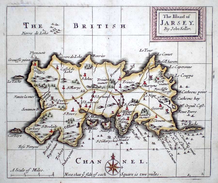
Jersey 'The Island of Jarsey by John Seller' Seller, J. (c. 1703) 15 x 13 Fine map by the Hydrographer and instrument maker John Seller for his "Anglia Contracta". The map is divided up into squares each side of which represents two miles. This series of maps were first published in 1695. They were later used in a simplified form by Francis Grose for his "Supplement to the Antiquities of England and Wales", published from 1787. 60.00 GBP |
|
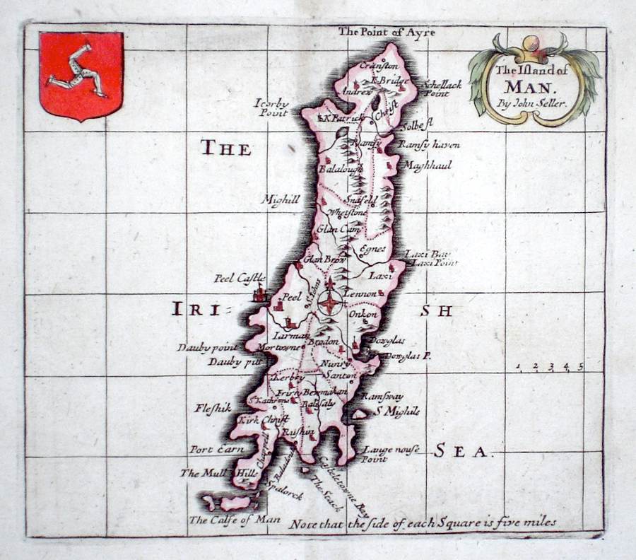
The British Isles 'The Island of Man by John Seller' Seller, J. (c. 1703) 15 x 13 Fine map by the Hydrographer and instrument maker John Seller for his "Anglia Contracta". The map is divided up into squares each side of which represents five miles. This series of maps were first published in 1695. They were later used in a simplified form by Francis Grose for his "Supplement to the Antiquities of England and Wales", published from 1787. 50.00 GBP |
|
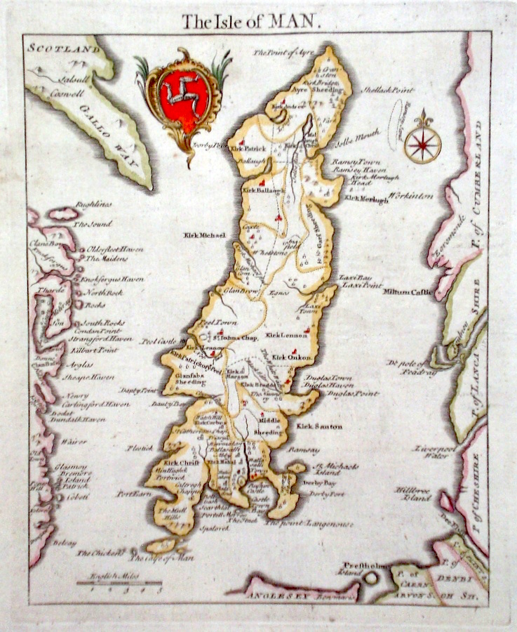
The British Isles 'Isle of Man' Cary, J. (1789) 15 x 18 Finely engraved map of the Island by John Cary for the first edition of Richard Gough's translation of Camden's Britannia. Excellent condition. Later colour 40.00 GBP |
|
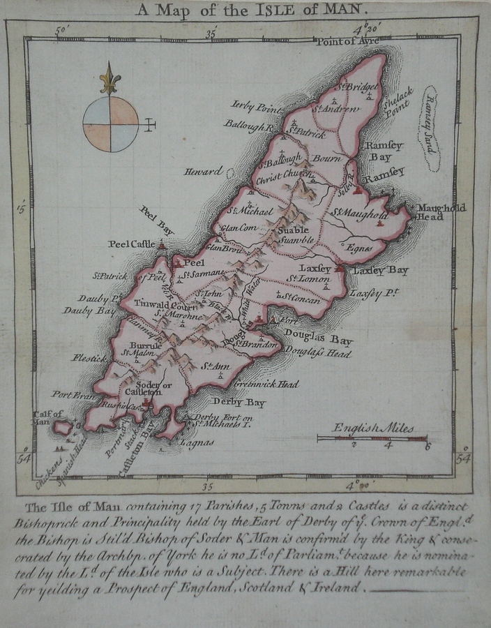
The British Isles 'A Map of the Isle of Man' Kitchin/Jefferys (1751) 13.5 x 18 Finely engraved map of the Island by Thomas Kitchin and Thomas Jefferys from their publication "The Small English Atlas". This rare series of maps are distinctive by featuring considerable local information below the map. Later colour 60.00 GBP |
|
The British Isles 'Isle of Man' Rocque, J. (c. 1769) 16 x 21 Finely engraved map of the county by John Rocque for the publication "England Displayed". Later colour. 50.00 GBP |
|
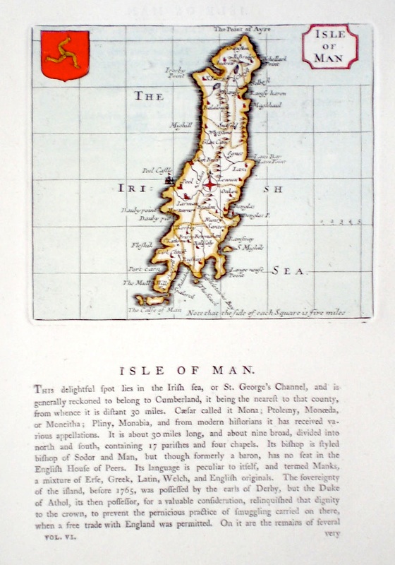
The British Isles 'Isle of Man' Seller, J. (c. 1700) 14 x 12 Early map of the Island by John Seller for Grose's Antiquities. Accompanying text gives considerable detail and is continued verso. Later colour 50.00 GBP |
|
The
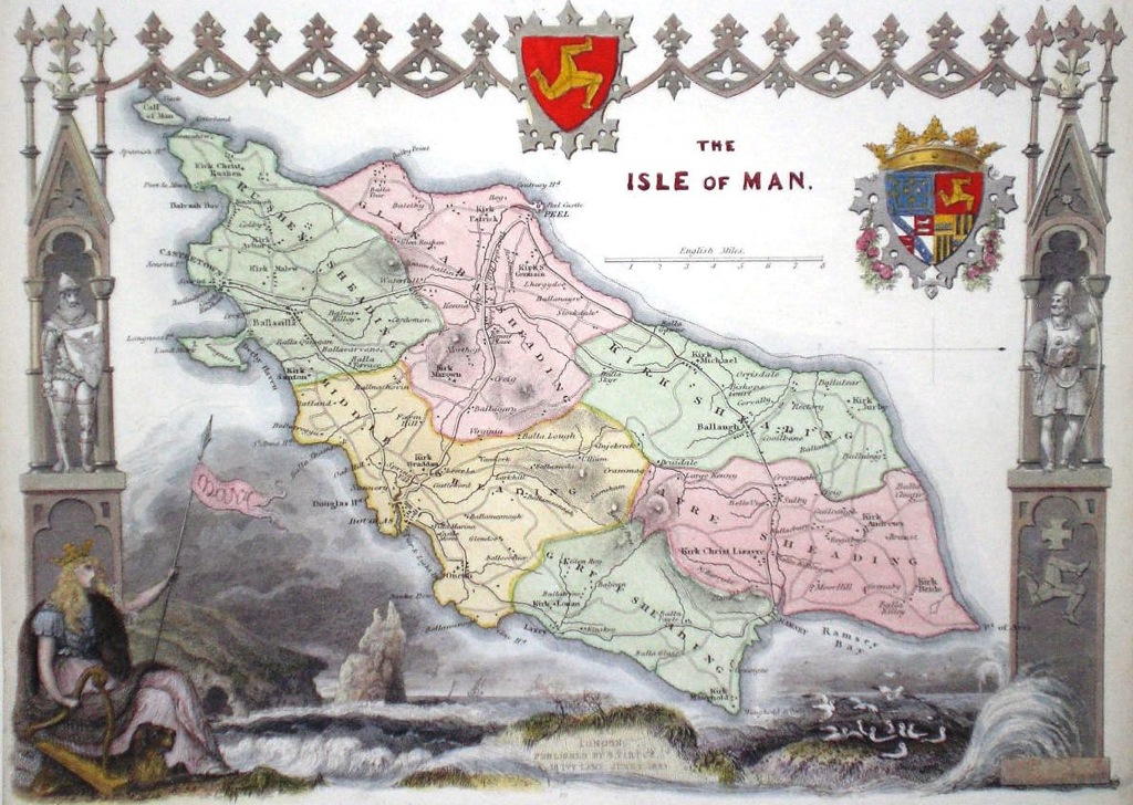
British Isles 'The Isle of Man' Bingley, J. (c. 1843) 27 x 19 Finely detailed steel engraved map of the Island by James Bingley for Thomas Moule. Originally issued in Moule's 'English Counties Delineated' Maps from this series are generally considered to be amoungst the most decorative issued in the nineteenth century. North is to the right. Later colour 50.00 GBP |
|
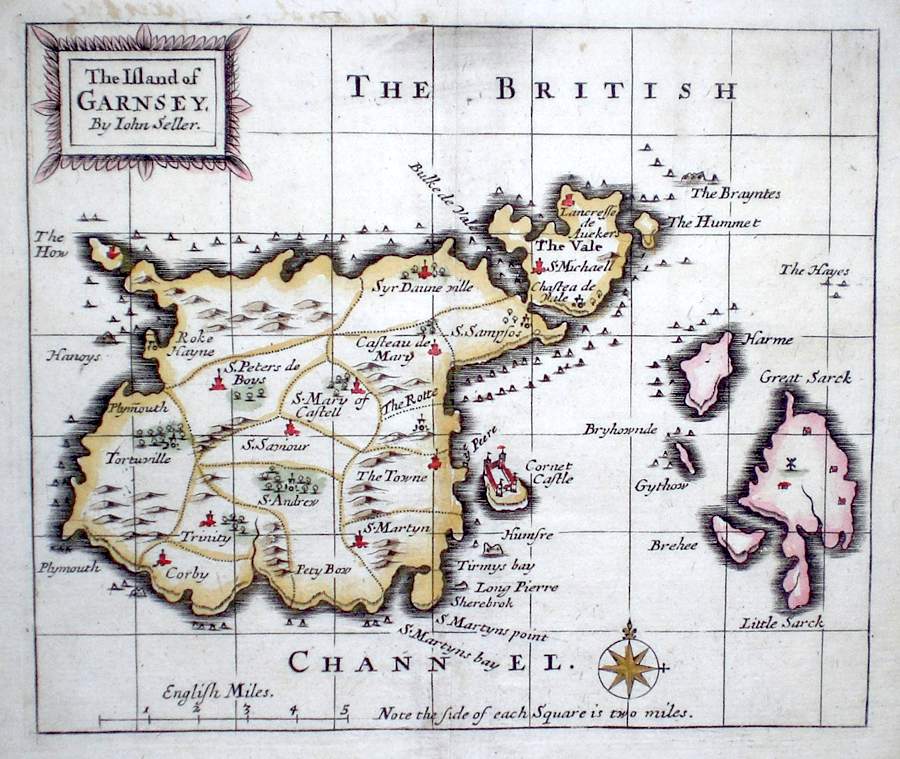
The British Isles 'The Island of Garnsey by John Seller' Seller, J. (c. 1703) 15 x 12 Fine map by the Hydrographer and instrument maker John Seller for his "Anglia Contracta". The map is divided up into squares each side of which represents two miles. This series of maps were first published in 1695. They were later used in a simplified form by Francis Grose for his "Supplement to the Antiquities of England and Wales", published from 1787. 60.00 GBP |
|
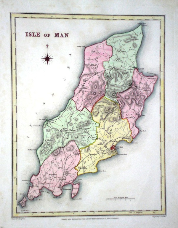
The British Isles 'Isle of Man' Walker, J. & C. (c. 1842) 18 x 24 Clearly engraved and stylish map of the Island by Samuel Lewis from his 'Topographical Dictionary'. Later colour. 35.00 GBP |
|
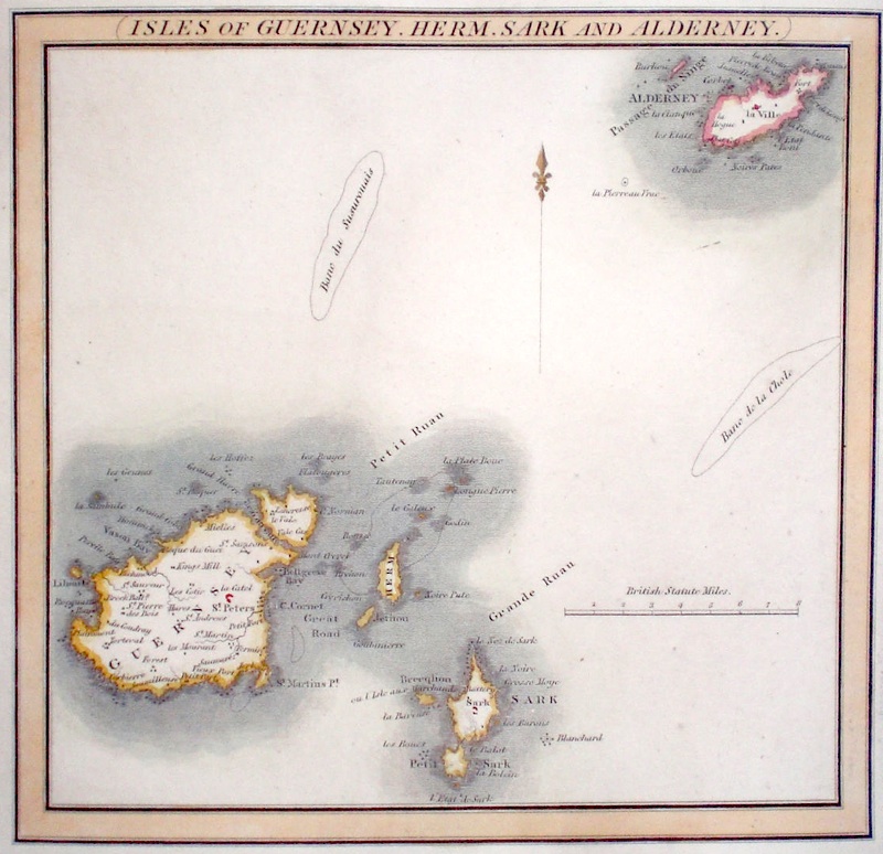
Channel Islands 'Isles of Guernsey. Herm. Sark and Alderney' Hewitt, N.R. (c. 1817) 19 x 18 Map of the Islands engraved by N. R. Hewitt for Thomson's General Atlas. Later colour 30.00 GBP |
|
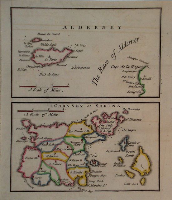
Channel Islands 'Alderney. Garnsey ot Sarina' Cary, J. Camden's Britannia (1789) 14.5 x 18 (total area) Maps of Guernsey/Sark and Alderney on one sheet. Later hand colour. 30.00 GBP |